Mapping Greenland’s ice layers in 3D
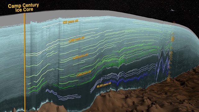
Using ice-penetrating radar and ice cores, NASA has been able to map the layers in the Greenland ice sheet.
This new map allows scientists to determine the age of large swaths of Greenland’s ice, extending ice core data for a better picture of the ice sheet’s history. “This new, huge data volume records how the ice sheet evolved and how it’s flowing today,” said Joe MacGregor, a glaciologist at The University of Texas at Austin’s Institute for Geophysics and the study’s lead author.
Greenland’s ice sheet is the second largest mass of ice on Earth, containing enough water to raise ocean levels by about 20 feet. The ice sheet has been losing mass over the past two decades and warming temperatures will mean more losses for Greenland. Scientists are studying ice from different climate periods in the past to better understand how the ice sheet might respond in the future.
One way of studying this distant past is with ice cores. These cylinders of ice drilled from the ice sheet hold evidence of past snow accumulation and temperature and contain impurities like dust and volcanic ash that were carried by snow that accumulated and compacted over hundreds of thousands of years. These layers are visible in ice cores and can be detected with ice-penetrating radar.
Ice-penetrating radar works by sending radar signals into the ice and recording the strength and return time of reflected signals. From those signals, scientists can detect the ice surface, sub-ice bedrock and layers within the ice.
New techniques used in this study allowed scientists to efficiently pick out these layers in radar data. Prior studies had mapped internal layers, but not at the scale made possible by these newer, faster methods. Another major factor in this study was the amount of Greenland IceBridge has measured.
It’s amazing that the detectors and data analysis are sensitive enough to pick out different layers in the ice just from radar. (via @ptak)
Stay Connected