kottke.org posts about archaeology

From the collection of the Met, an Egyptian artist’s sketch of a sparrow circa 1479–1458 BCE. Much of the art that filters down to us from ancient civilizations was used for official purposes (state, religion, commerce); it’s nice to see something simpler like this drawing. Archaeologist Alison Fisk:
This may have been a practice drawing of the sparrow hieroglyph which was used for words meaning ‘small’, ‘poor’, or ‘bad’
The Egyptian artisans who decorated tombs and temples, drew sketches and jotted down notes on the plentiful limestone flakes which were by-products of temple and rock-cut tomb construction. Egyptologists refer to them as ‘ostraca’ (singular: ostracon). More info: ancientegyptonline.co.uk/ostracon/
From that link about ostracon:
The word “ostracon” is derived from the Greek “ostrakon” (meaning a piece of pottery used as a voting ballot). When a vote was held on whether to banish a person from society these shards were used to cast votes. This is the origin of the word “ostracism” (literally meaning “to be voted out”).
Carl Zimmer writes about the results of a new genetic study of humans and the diseases that afflicted us over the past 37,000 years. It’s a really fascinating read — in part because of how scientific results can defy our expectations. For instance, the researchers expected to find the plague when people first started domesticating animals 11,000 years ago. But they didn’t:
But the ancient DNA defied that expectation. The scientists found that plague and a number of other diseases jumped to people from animals thousands of years later, starting about 6,000 years ago. And those microbes did not jump into early farmers.
Instead, the new study points to nomadic tribes in Russia and Asia. Thousands of years after the dawn of agriculture, those nomads started rearing vast herds of cattle and other livestock.
And then:
Those epidemics were so intense that they changed the genetic profile of the nomads. Last year, Dr. Willerslev and his colleagues found that the nomads experienced a spike in mutations that boosted their immune system and that may have helped them resist the diseases they contracted. But their active immune systems may have also attacked their own bodies, producing chronic diseases such as multiple sclerosis.
These diseases might have played a part in Bronze Age history. In previous research, Dr. Willerslev and other scientists have found evidence that nomads expanded from the steppes of Asia into Europe about 4,500 years ago.
The study published on Wednesday suggests that the nomads may have gotten help from their pathogens. European farmers and hunter-gatherers had not evolved resistance to diseases such as plague and may have died off in huge numbers, making it easier for the nomads to move in.
Read the whole thing — it’s interesting throughout.
Researchers from the Freie Universität Berlin working in the Netherlands recently found a little bone container full of drugs in a pile of 86,000 other bones they had found outside a farm in what is now the Dutch city of Utrecht. Initially the researchers missed the find because they weren’t looking for a first century C.E. bone full of drugs in a bone stack (that’s a needle in a haystack joke I was afraid you wouldn’t get, so I’m just pointing it out, but if you did get it, I’m sorry for not trusting you as a reader.).
The bone container, discovered when a birch pitch plug was dislodged, was full of black hebane seeds which back in the olden olden olden days was used for “relieving pain and helping with difficult pregnancies. Yet ingesting too much, one Roman author wrote, could lead to “alienation of [the] mind or madness”.”
Ancient Roman authors were clearly familiar with the plant. Pliny the Elder, Plutarch, and others wrote about black henbane, along with its closely related but less potent relatives, white and yellow henbane. These plants—in the form of ointments, potions, or burning smoke—were prescribed for everything from earaches and toothaches to flatulence and “pains of the womb.” Ancient scholars also warned against taking too much because of the potential for hallucinogenic effects; Pliny counseled physicians to avoid it entirely.

This quotation submitted without comment: “When you think about how much was in there, your imagination really goes wild.”
This video submitted without comment, as well:

Using lidar, a team led by archaeologist Stéphen Rostain has found evidence of a network of cities in the Amazon dating back thousands of years. From the BBC:
Using airborne laser-scanning technology (Lidar), Rostain and his colleagues discovered a long-lost network of cities extending across 300sq km in the Ecuadorean Amazon, complete with plazas, ceremonial sites, drainage canals and roads that were built 2,500 years ago and had remained hidden for thousands of years. They also identified more than 6,000 rectangular earthen platforms believed to be homes and communal buildings in 15 urban centres surrounded by terraced agricultural fields.
The area may have been home to anywhere from 30,000 to hundreds of thousands of people:
“This discovery has proven there was an equivalent of Rome in Amazonia,” Rostain said. “The people living in these societies weren’t semi-nomadic people lost in the rainforest looking for food. They weren’t the small tribes of the Amazon we know today. They were highly specialised people: earthmovers, engineers, farmers, fishermen, priests, chiefs or kings. It was a stratified society, a specialised society, so there is certainly something of Rome.”
You can read more coverage of this in New Scientist, the NY Times, Science, and the Guardian.
I still remember reading Charles Mann’s Earthmovers of the Amazon (which he turned into the excellent 1491) almost 25 years ago and being astounded to learn that civilizations in the Americas were older, larger, and more widespread than I’d been taught.
In the past few decades, we’ve found out a great deal about pre-Columbian civilizations & inhabitants of the Americas, including those in the Amazon rainforest, where settlements were larger and more numerous than previously believed.
When European colonizers arrived in the 16th century, they were captivated by rumors of a golden city, hidden somewhere in the rainforest. Their search for “El Dorado” lasted more than a century, but only resulted in disaster, death, and further conquest of the indigenous people there.
Experts thereafter looked at the Amazon and saw only a desolate jungle; too harsh for extensive agriculture and therefore sparsely populated. They believed that it had always been this way.
Until recently.
Beginning in the late 20th century, archaeologists began looking more closely at the forest floor. Working with the indigenous people who still remained there, they excavated long ditches and mounds. After mapping them, they could see that these were the markings of large settlements; walls, moats, plazas, and roads that connected even more settlements. And they were all over the Amazon.
Ernest Shackleton’s ship, The Endurance, has been lost since it sank in the Antarctic in 1915. A team of explorers and researchers just found it in icy waters 10,000 feet beneath the surface.
The ship was found about four miles south of the last location recorded by Shackleton’s captain and navigator, Frank Worsley. The search had been conducted over a wide area to account for errors in Worsley’s navigation equipment.
Endurance’s relatively pristine appearance was not unexpected, given the cold water and the lack of wood-eating marine organisms in the Weddell Sea that have ravaged shipwrecks elsewhere.
Mr. Bound also described the wreck as “intact.” Although Hurley’s photographs before the sinking had shown major damage to, and the collapse of, the ship’s mast and rigging, and there had been damage to the hull, Mr. Bound had expected most of the ship to be in one piece.
The video above was taken by the underwater drones that found the wreck.
Using samples of chopped-down wood left behind by Viking explorers at their settlement in Newfoundland and known chemical markers of powerful solar storms in 993 AD, a group of scientists has determined the exact timing of the first-known visit of Europeans to North America: 1021 AD. If you’re keeping score at home, that’s 471 years before Columbus.
A team of scientists looked at wood found at the L’Anse aux Meadows Viking site. In three cases the trees had been physically cut down, and moreover, they were clearly cut with metal tools — Vikings had metal implements at the time, but indigenous people did not. The wood was all from different trees (one was fir, and another juniper, for example). The key parts here are that the wood was all from trees that had been alive for many decades, and all had their waney edge intact as well.
The scientists extracted 127 samples from the wood, and 83 rings were examined. They used two methods to secure dates. The first was to compare the amount of carbon-14 in each ring with known atmospheric amounts from the time. This gives a rough date for the waney edge of the wood. They also then looked for an anomalous spike in carbon-14 in an inner ring, knowing this would have come from the 993 A.D. event, and then simply counted the rings outward from there to get the date of the waney edge.
In all three samples the waney edge was dated to the same year: 1021 A.D. This would be incredibly unlikely to occur at random.
Outstanding science. It’s incredible how much of a time machine these analysis tools are. There’s so much we don’t know about people who lived 1000 years ago, but it’s astounding that we know anything at all, particularly precise dates like this.
Update: From this Ars Technica piece, some more information on the precision of the dating:
Based on the development stages of certain cells in the waney layer, Dee, Kuitems, and their colleagues say that one of the trees was cut down in the spring, while another was cut down in the summer or fall. The third tree’s final season couldn’t be identified because the cells had been damaged by a conservation treatment, but the results suggest that the Norse cut down these trees within a few months of each other in 1021.
That lends additional support to the other evidence that the Norse only stayed in Newfoundland for a few years.
“One would imagine the dates would have been different if the occupation period of the site was very long,” Dee told Ars. “However, the fact all three of our samples produced the same date does not, of course, mean the site was only occupied for one year. It may indeed have been occupied longer. But I think it is true to say our results support a short occupation.”
A pair of 1300-year-old skis has been discovered in an ice field in Norway. They are believed to be the best-preserved ancient skis ever found — even the bindings are mostly intact. The first of the pair was found back in 2014 and its mate was recently retrieved, an expedition you can witness in the video above.
It has been seven years since the discovery of the first ski at the Digervarden ice patch. We have patiently monitored the melt of the ice patch, in case the second ski of the pair should melt out. We were back in 2016 for a general survey of the ice patch, but the ice had not retreated much then. This year, we could see on satellite imagery that the ice patch had retreated compared to 2014. We decided to send out an archaeologist to check it.
One of the things they were hoping to find is how the skier was able to maintain forward motion with the skis, especially uphill. Modern cross-country skis rely on a texture (or wax) on the bottom of the ski to grip the snow while downhill skiers can apply skins to their skis to climb uphill. More than a thousand years ago, the choice was texture or animal fur:
One of the questions raised by the ski found in 2014 was if it originally had fur on the underside. This has major implications for the use of the ski. There were no nail holes along the sides of the 2014 ski which would have been a clear sign of the fastening of the fur. However, fur can also be glued to the underside, so we could not rule it out.
A furrow on the underside along the length of the ski, as you find on other prehistoric skis (and on modern cross-country skis), would solve the question. Such a furrow would have no function with an underside covered by fur. The 2014 ski did not show a furrow, but the new and better preserved ski does! So, probably no fur-lining.
(thx, meg)
The Artifact Artist is a short documentary about urban archaeologist Scott Jordan, who, over the past 50 years in NYC, has dug up all sorts of historical objects that date back decades and centuries, even all the way back to the Revolutionary War. The trailer is above and you can watch the entire short film on Vimeo.
Uprooted from the forests of Connecticut to move to New York City, 9 yr. old Scott Jordan declares “I won’t be a city kid!” 45 yrs. later Scott is an urban archeologist. An Indiana Jones in Gotham. Hand digging out centuries old privies, cisterns and landfills across the five boroughs Scott is uncovering artifacts and preserving New York City history by creating artifact art with the treasures he discovers.
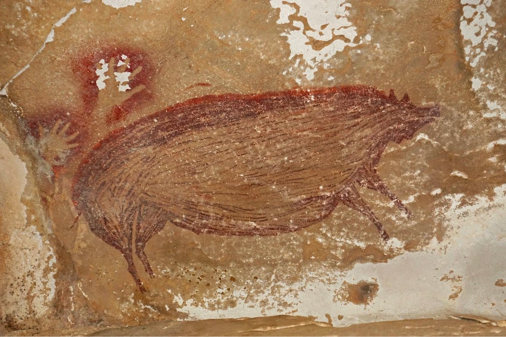
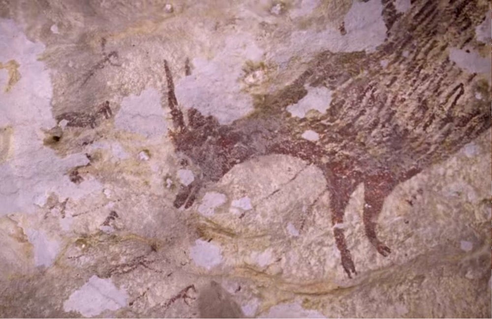
According to a study published this week, archaeologists have determined that a recently discovered cave painting of a warty pig is at least 45,500 years old. From the NY Times:
In a hidden valley on an Indonesian island, there is a cave decorated with what may be the oldest figurative art ever glimpsed by modern eyes.
The vivid depiction of a wild pig, outlined and filled in with mulberry-hued pigment, dates back at least 45,500 years, according to a study published on Wednesday in Science Advances. It was discovered deep inside a cave called Leang Tedongnge in December 2017, during an archaeological survey led by Basran Burhan, a graduate student at Griffith University and co-author of the new research. The animal in the painting resembles the warty pig, a species still living today on the island of Sulawesi where the cave is.
Still up for debate: who painted it? Not the individual who painted it — we’ll never know that — but what species painted it.
Human skeletal remains as old as 45,500 years have never been found in Sulawesi, so it is not clear that the artists were anatomically modern humans. The islands that are now called Indonesia were inhabited by different hominins — the broader family to which humans belong — over long periods of time. Some of these hominin remains date “to over a million years old,” said Rasmi Shoocongdej, an archaeologist at Silpakorn University in Thailand who was not involved in the study.
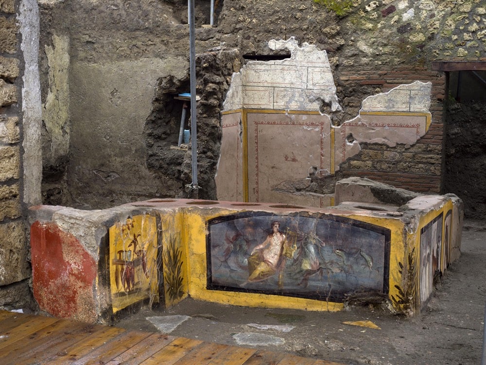
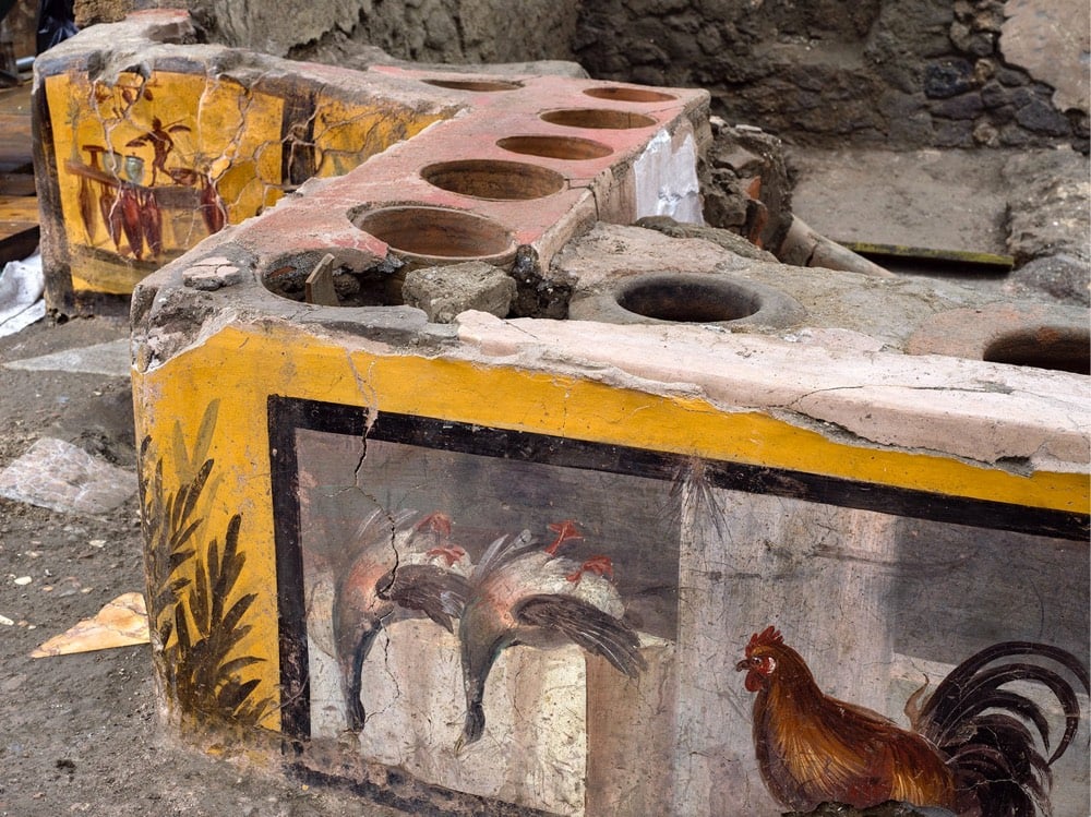
This was widely shared last week but I wanted to post about it anyway in case you didn’t see it because it seems just so strikingly contemporary: a Roman snack bar from 79 ACE was recently unearthed in Pompeii.
In this new phase of excavation, the last section of the counter to be unearthed revealed other exquisite scenes of still life, with depictions of animals which were likely butchered and sold here. Bone fragments belonging to the same animals were also discovered inside containers embedded in the counter, which held foodstuffs intended for sale, such as in the case of the two mallard ducks shown upside down, ready to be cooked and eaten; a rooster; and a dog on a lead, the latter serving almost as a warning in the manner of the famed Cave Canem.
The photos are blowing my mind here. You never really think about the to-go food stall as an architectural archetype — much less one that’s 2000 years old — but all the elements are right there. It doesn’t look so much different from a hot food bar at an NYC bodega or Whole Foods. Archaeologists also found graffiti scrawled on the wall of the snack bar, just like that on the walls & tables of a place like John’s Pizzeria. You could completely imagine yourself standing there, two millennia ago, looking at the pictures and containers of what’s on offer, ordering some lunch, and chuckling at the graffiti with a pal.
A team of archaeologists has found a massive painting in a cave in Indonesia that uranium dating analysis shows to be around 43,900 years old, which they say is “currently the oldest pictorial record of storytelling and the earliest figurative artwork in the world”.
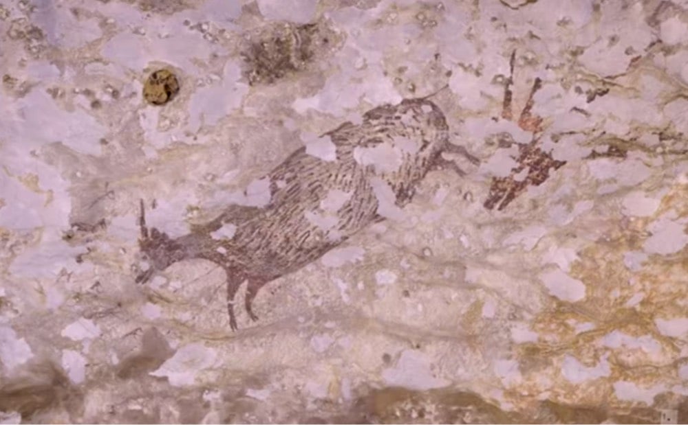
Cave painting was assumed to have originated in Europe, but these Indonesian paintings are thousands of years older. From an NPR piece on the discovery:
Genevieve von Petzinger, a paleoanthropologist at the University of Victoria, says the discoveries in her field are happening very quickly, thanks to newer technology such as the technique used to date the hunting scene. “I think the overall theme here really is that we’ve vastly underestimated the capacity of our ancestors,” she says.
She says the oldest cave paintings in Europe and Asia have common elements. And she thinks that even older paintings will eventually be found in the place where both groups originated from.
“Personally, I think that our ancestors already knew how to do art before they left Africa,” von Petzinger says.
Von Petzinger is the scientist behind one of the most intriguing things I learned this year, that the Stone Age symbols found in caves all over the world may be part of a single prehistoric writing system.
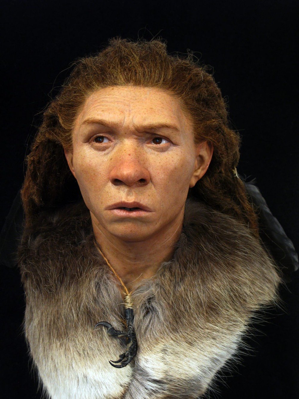
Working from remains discovered during archaeological excavations, sculptor and archaeologist Oscar Nilsson combines his two disciplines to reconstruct the faces of people who lived hundreds, thousands, and even tens of thousands of years ago.
This Neanderthal woman lived 45-50,000 years ago:
This young woman lived in what is now Britain about 5500 years ago. DNA evidence shows that the skin color of the region’s inhabitants at the time was quite dark, akin to that of modern North Africans.
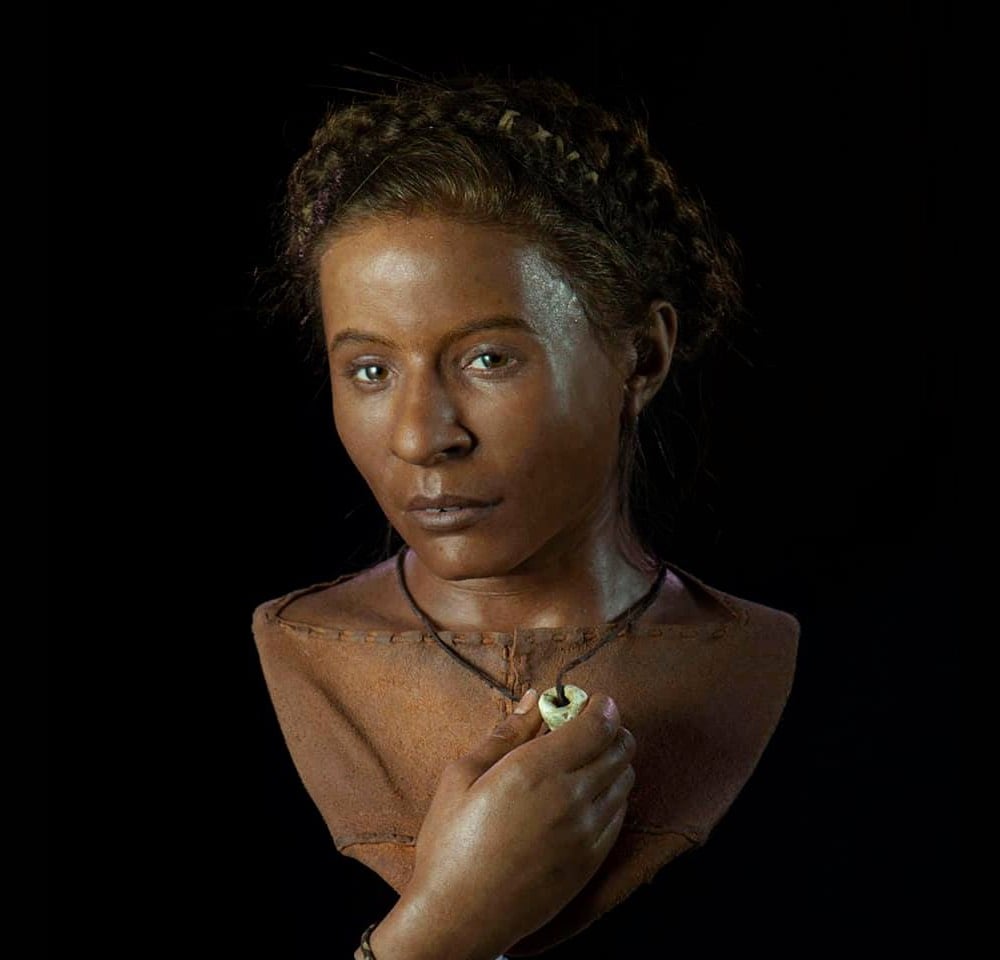
This man was around 20 when he died in northern Switzerland 1300 years ago. His skull was unusual in that it contained a full set of perfect teeth.

You can read more about Nilsson’s restorations at Facebook and National Geographic.
Nilsson’s forensic technique starts with an exact 3D replica of the original skull, scanned, printed, and then modeled by hand to reflect bone structure and tissue thickness based on the individual’s origin, sex, and estimated age at death.
Recent genome studies of ancient European populations enable Nilsson to outfit his reconstructions with reasonably accurate estimates of skin, hair, and eye color. The Neolithic population that the 5,600-year-old Whitehawk woman belonged to, for instance, generally had lighter skin and darker eyes than earlier occupants of Britain such as Cheddar Man, but were darker than the exhibit’s Ditchling Road man, who arrived on the island in the first wave of light-skinned, light-eyed Beaker people from continental Europe around 4,400 years ago.
Archaeologists are increasingly looking past the splashy artifacts of ancient elites to seek & find the dwellings and possessions of commoners. For Knowable Magazine (good title), Bob Holmes talked to retired archaeologist Jeremy Sabloff about the Archaeology of the 99%.
Archaeology frequently focused on big buildings and objects owned by elites because they were easier to find and more durable & abundant (elites had money to spend on nice things). But it was also a question of where the funding came from:
Before World War II, archaeological research was funded mostly by museums or wealthy individuals or foundations. They wanted spectacular finds — temples and palaces, not the remains of perishable structures of everyday life. They wanted royal burials, such as King Tut’s tomb, the royal treasures of Ur, great sculpture, murals, beautiful pottery, jade, what have you. They were looking for materials that they could bring back and display in museums.
Then a shift happened:
The makeup of the field changed significantly after World War II, and its practitioners became much more middle class. One reason is there were a lot more jobs available, particularly at state universities. And you started to be able to get grants for fieldwork that wasn’t based on looking for objects or spectacular finds.
And new technology has helped as well:
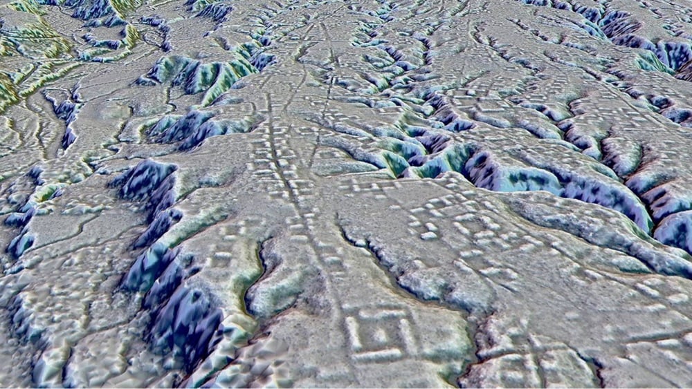
The richer picture we’re getting of the 100 percent is aided by tools that archaeologists 50 years ago just didn’t have available. In terms of settlement-pattern mapping, one of the huge technical breakthroughs in recent years is remote sensing, particularly LIDAR, where low-flying aircraft or drones send down laser beams and you can see the ground without the trees. You can see stone courses. You can see the remains of houses, causeways, roads, defensive fortifications. That’s going to make the mapping of sites much simpler, particularly in difficult situations like tropical rainforest or a heavily wooded area. We’re able to cover much bigger areas with much greater detail and accuracy than ever before.
I am reading Mary Beard’s SPQR: A History of Ancient Rome right now and in the first chapter she touches on what we know about ordinary Romans:
The reasons why we can tell this story in such detail are very simple: the Romans themselves wrote a great deal about it, and a lot of what they wrote has survived. Modern historians often lament how little we can know about some aspects of the ancient world. ‘Just think of what we don’t know about the lives of the poor,’ they complain, ‘or of the perspectives of women.’ This is as anachronistic as it is deceptive. The writers of Roman literature were almost exclusively male; or, at least, very few works by women have come down to us (the autobiography of the emperor Nero’s mother, Agrippina, must count as one of the saddest losses of classical literature). These men were also almost exclusively well off, even though some Roman poets did like to pretend, as poets still occasionally do, that they were starving in garrets. The complaints, however, miss a far more important point.
The single most extraordinary fact about the Roman world is that so much of what the Romans wrote has survived, over two millennia. We have their poetry, letters, essays, speeches and histories, to which I have already referred, but also novels, geographies, satires and reams and reams of technical writing on everything from water engineering to medicine and disease. The survival is largely due to the diligence of medieval monks who transcribed by hand, again and again, what they believed were the most important, or useful, works of classical literature, with a significant but often forgotten contribution from medieval Islamic scholars who translated into Arabic some of the philosophy and scientific material. And thanks to archaeologists who have excavated papyri from the sands and the rubbish dumps of Egypt, wooden writing tablets from Roman military bases in the north of England and eloquent tombstones from all over the empire, we have glimpses of the life and letters of some rather more ordinary inhabitants of the Roman world. We have notes sent home, shopping lists, account books and last messages inscribed on graves. Even if this is a small proportion of what once existed, we have access to more Roman literature — and more Roman writing in general — than any one person could now thoroughly master in the course of a lifetime.
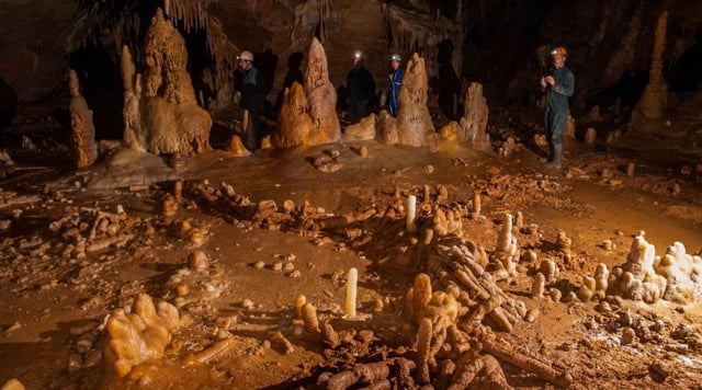
While exploring the ground underneath the ancient Mayan city of Chichén Itzá in Mexico, archaeologists found a ritual chamber stuffed with artifacts untouched for more than 1000 years.
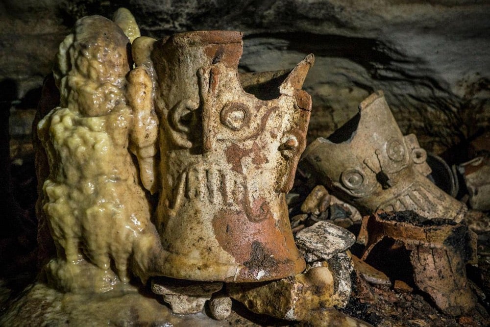
De Anda recalls pulling himself on his stomach through the tight tunnels of Balamku for hours before his headlamp illuminated something entirely unexpected: A cascade of offerings left by the ancient residents of Chichén Itzá, so perfectly preserved and untouched that stalagmites had formed around the incense burners, vases, decorated plates, and other objects in the cavern.
“I couldn’t speak, I started to cry. I’ve analyzed human remains in [Chichén Itzá’s] Sacred Cenote, but nothing compares to the sensation I had entering, alone, for the first time in that cave,” says de Anda, who is an investigator with INAH and director of the Great Maya Aquifer Project, which seeks to explore, understand, and protect the aquifer of Mexico’s Yucatan Peninsula.
“You almost feel the presence of the Maya who deposited these things in there,” he adds.
Oddly, the cave was explored by an archaeologist back in 1966, but he ordered the entrance sealed up and the chamber and the objects contained within were forgotten until now.
While studying some of the oldest art in the world found in caves and engraved on animal bones or shells, paleoanthropologist Genevieve von Petzinger has found evidence of a proto-writing system that perhaps developed in Africa and then spread throughout the world.

The research also reveals that modern humans were using two-thirds of these signs when they first settled in Europe, which creates another intriguing possibility. “This does not look like the start-up phase of a brand-new invention,” von Petzinger writes in her recently published book, The First Signs: Unlocking the mysteries of the world’s oldest symbols (Simon and Schuster). In other words, when modern humans first started moving into Europe from Africa, they must have brought a mental dictionary of symbols with them.
That fits well with the discovery of a 70,000-year-old block of ochre etched with cross-hatching in Blombos cave in South Africa. And when von Petzinger looked through archaeology papers for mentions or illustrations of symbols in cave art outside Europe, she found that many of her 32 signs were used around the world. There is even tantalising evidence that an earlier human, Homo erectus, deliberately etched a zigzag on a shell on Java some 500,000 years ago. “The ability of humans to produce a system of signs is clearly not something that starts 40,000 years ago. This capacity goes back at least 100,000 years,” says Francesco d’Errico from the University of Bordeaux, France.
Nonetheless, something quite special seems to have happened in ice age Europe. In various caves, von Petzinger frequently found certain symbols used together. For instance, starting 40,000 years ago, hand stencils are often found alongside dots. Later, between 28,000 and 22,000 years ago, they are joined by thumb stencils and finger fluting — parallel lines created by dragging fingers through soft cave deposits.
Von Petzinger lays out the results of her work in a 2016 book called The First Signs: Unlocking the Mysteries of the World’s Oldest Symbols and in a TED Talk from 2015:
It’s not writing (because the symbols don’t appear to be capable of representing the full range of spoken language) and it’s not an alphabet, but it’s definitely an intriguing something. (via open culture)
Wow! Genetic analysis of a human bone fragment found in Siberia reveals that her parents belonged to two different groups of humans: her father was Denisovan and her mother Neanderthal.
A female who died around 90,000 years ago was half Neanderthal and half Denisovan, according to genome analysis of a bone discovered in a Siberian cave. This is the first time scientists have identified an ancient individual whose parents belonged to distinct human groups. The findings were published on 22 August in Nature1.
“To find a first-generation person of mixed ancestry from these groups is absolutely extraordinary,” says population geneticist Pontus Skoglund at the Francis Crick Institute in London. “It’s really great science coupled with a little bit of luck.”
Luck is right…what a needle in a haystack.
Based on the available archaeological evidence, researchers had assumed that bread and agriculture developed around the same time. But a recent find in Jordan of a 14,500-year-old flatbread indicates that bread was first made some 4000 years before agriculture was invented.
No matter how you slice it, the discovery detailed on Monday shows that hunter-gatherers in the Eastern Mediterranean achieved the cultural milestone of bread-making far earlier than previously known, more than 4,000 years before plant cultivation took root.
The flatbread, likely unleavened and somewhat resembling pita bread, was fashioned from wild cereals such as barley, einkorn or oats, as well as tubers from an aquatic papyrus relative, that had been ground into flour.
And now researchers are wondering, did the invention of bread drive the invention agriculture?
“We now have to assess whether there was a relationship between bread production and the origins of agriculture,” Arranz-Otaegui said. “It is possible that bread may have provided an incentive for people to take up plant cultivation and farming, if it became a desirable or much-sought-after food.”
University of Copenhagen archeologist and study co-author Tobias Richter pointed to the nutritional implications of adding bread to the diet. “Bread provides us with an important source of carbohydrates and nutrients, including B vitamins, iron and magnesium, as well as fibre,” Richter said.
I don’t know who my old favorite archaeologist was, but my new favorite archaeologist is Doris Jones. Jones is 90 years old and is one of the top volunteer space archaeologists on GlobalXplorer, a site that crowdsources the process of locating potential archaeological sites on satellite imagery. People like Jones look at satellite images for telltale signs of past human activity and promising locations are then passed on to field archaeologists working in the area.

From Expedia, a series of animated GIFs that show what ancient ruins from around the world would look like if they were restored. They did The Parthenon (above), Pompei’s Temple of Jupiter, Hadrian’s Wall, the Luxor Temple in Eqypt, and the Nohoch Mul Pyramid in Mexico:
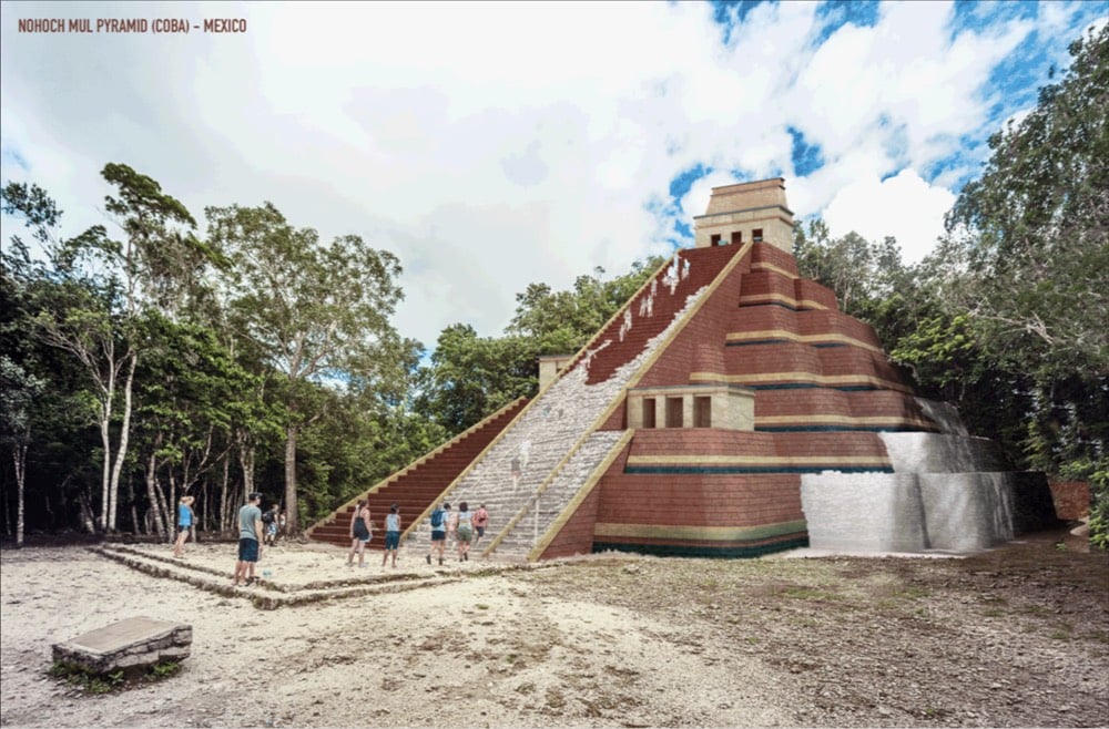
I climbed Nohoch Mul during a recent visit to Coba. (via colossal)
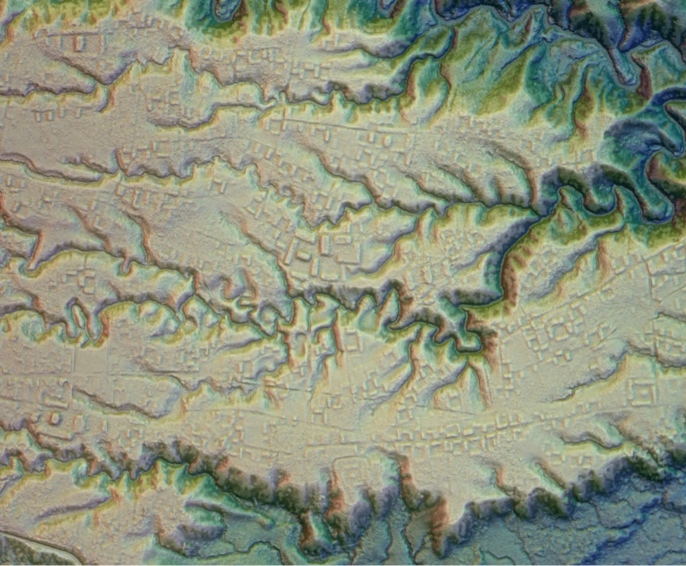
Using LIDAR, a team of researchers in Guatemala has been able to peer underneath the dense jungle to see what the landscape looked like in the time of the Mayans, a civilization which reached its peak between 250-900 A.D. — an x-ray of the forest, if you will. The results are astonishing…they reveal a civilization much larger and more sophisticated than previously thought.
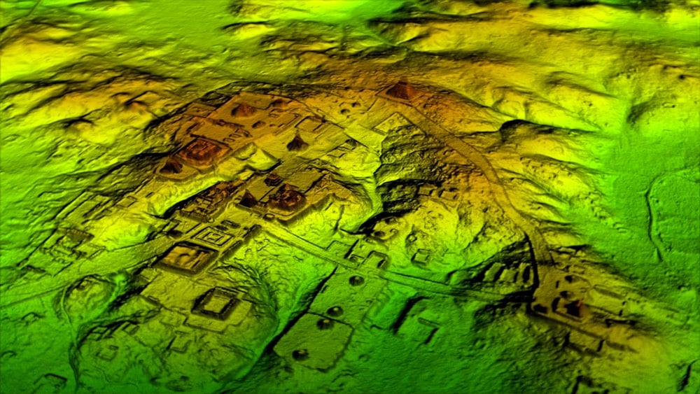
The results suggest that Central America supported an advanced civilization that was, at its peak some 1,200 years ago, more comparable to sophisticated cultures such as ancient Greece or China than to the scattered and sparsely populated city states that ground-based research had long suggested.
In addition to hundreds of previously unknown structures, the LiDAR images show raised highways connecting urban centers and quarries. Complex irrigation and terracing systems supported intensive agriculture capable of feeding masses of workers who dramatically reshaped the landscape.
The potential of LIDAR as a cultural and geological time machine is just starting to be realized. You might remember these LIDAR images of the geology of forested areas in Washington State.
Update: Another team, working in Mexico, recently used LIDAR to uncover a city built by the Purépecha civilization that had as many buildings as modern-day Manhattan.
DNA analysis of remains found at archaeological sites is changing the story of how humans populated the Americas. Analysis of a pair of infants found in Alaska suggests that only one wave of humans settled the Americas around 20,900 years ago.
Genetic evidence published today in Nature is the first to show that all Native Americans can trace their ancestry back to a single migration event that happened at the tail-end of the last Ice Age. The evidence — gleaned from the full genomic profile of the six-week-old girl and the partial genomic remains of another infant — suggests the continent’s first settlers arrived in a single migratory wave around 20,900 years ago. But this population then split into two groups — one group that would go on to become the ancestors of all Native North Americans, and another that would venture no further than Alaska — a previously unknown population of ancient North Americans now dubbed the “Ancient Beringians.”
(via clive thompson)
The prevailing theory of how the Americas were settled has been than human hunters followed big game across the ice-free land bridge between North America and Asia around 13,000 years ago. These are the Clovis people you may have learned about in school. But evidence is mounting that the first humans to settle the Americas came down the Pacific Coast somewhat earlier than that.
The Cedros Island sites add to a small but growing list that supports a once-heretical view of the peopling of the Americas. Whereas archaeologists once thought that the earliest arrivals wandered into the continent through a gap in the ice age glaciers covering Canada, most researchers today think the first inhabitants came by sea. In this view, maritime explorers voyaged by boat out of Beringia — the ancient land now partially submerged under the waters of the Bering Strait — about 16,000 years ago and quickly moved down the Pacific coast, reaching Chile by at least 14,500 years ago.
Part of the problem in confirming this hypothesis is that the rise in sea level that accompanied the melting of the glaciers (a 120-meter rise globally) submerged likely settlement sites, trapping archeological evidence under hundreds of feet of ocean. (via @CharlesCMann)
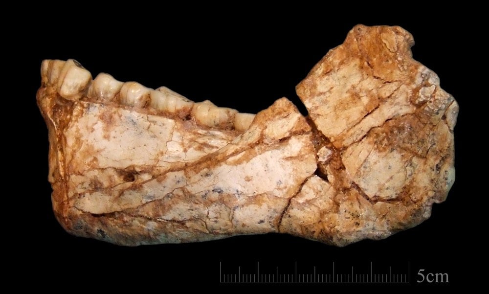
The oldest known fossils of homo sapiens have been found in Morocco. The bones date back to ~300,000 years ago, more than 100,000 years earlier than previous fossils found. Here’s Carl Zimmer reporting for the NY Times about the paper in Nature:
Dating back roughly 300,000 years, the bones indicate that mankind evolved earlier than had been known, experts say, and open a new window on our origins.
The fossils also show that early Homo sapiens had faces much like our own, although their brains differed in fundamental ways.
Until now, the oldest fossils of our species, found in Ethiopia, dated back just 195,000 years. The new fossils suggest our species evolved across Africa.
“We did not evolve from a single cradle of mankind somewhere in East Africa,” said Phillipp Gunz, a paleoanthropologist at the Max Planck Institute for Evolutionary Anthropology in Liepzig, Germany, and a co-author of two new studies on the fossils, published in the journal Nature.
The previous oldest fossils were found clear across the continent in Ethiopia, in eastern Africa. From a New Yorker article on the discovery:
And the specimens in question were found not in East Africa, which has become synonymous with a sort of paleoanthropological Garden of Eden, but clear on the other side of the continent — and the Sahara — in Morocco. “We’re not claiming that Morocco is the cradle of modern humankind,” the lead author, Jean-Jacques Hublin, of the Max Planck Institute for Evolutionary Anthropology, said at a press conference yesterday. Rather, he added, our emergence as a species was pan-African. “There is no Garden of Eden in Africa — or if there is, it’s Africa,” Hublin said. “The Garden of Eden is the size of Africa.”
Research on an arrangement of massive granite blocks in the Brazilian Amazon has indicated that they were used as an astronomical observatory about 1000 years ago.
After conducting radiocarbon testing and carrying out measurements during the winter solstice, scholars in the field of archaeoastronomy determined that an indigenous culture arranged the megaliths into an astronomical observatory about 1,000 years ago, or five centuries before the European conquest of the Americas began.
Their findings, along with other archaeological discoveries in Brazil in recent years — including giant land carvings, remains of fortified settlements and even complex road networks — are upending earlier views of archaeologists who argued that the Amazon had been relatively untouched by humans except for small, nomadic tribes.
I still remember reading Charles Mann’s piece in 2002 about the mounting evidence against the idea of a largely wild and pristine pair of continents civilized and tamed by Europeans.
Erickson and Balée belong to a cohort of scholars that has radically challenged conventional notions of what the Western Hemisphere was like before Columbus. When I went to high school, in the 1970s, I was taught that Indians came to the Americas across the Bering Strait about 12,000 years ago, that they lived for the most part in small, isolated groups, and that they had so little impact on their environment that even after millennia of habitation it remained mostly wilderness. My son picked up the same ideas at his schools. One way to summarize the views of people like Erickson and Balée would be to say that in their opinion this picture of Indian life is wrong in almost every aspect. Indians were here far longer than previously thought, these researchers believe, and in much greater numbers. And they were so successful at imposing their will on the landscape that in 1492 Columbus set foot in a hemisphere thoroughly dominated by humankind.
That article turned into 1491, which remains one of my favorite books.
See also Ars Technica’s recent piece Finding North America’s lost medieval city.
In the 90s, Bruniquel Cave was discovered to have a chamber containing an interesting human-built structure made from broken stalagmites. Carbon dating of a burnt bear bone within the chamber put the age of the activity at 47,600 years ago, smack dab in the Neanderthal era in that area. But recently, after a lull in research about these cave structures, analysis of uranium levels in the broken stalagmites resulted in a much older date for the construction: 176,500 years ago.
Nor is it clear how the Neanderthals made the structures. Verheyden says it couldn’t have been one lone artisan, toiling away in the dark. Most likely, there was a team, and a technically skilled one at that. They broke rocks deliberately, and arranged them precisely. They used fire, too. More than 120 fragments have red and black streaks that aren’t found elsewhere in the chamber or the cave beyond. They were the result of deliberately applied heat, at intensities strong enough to occasionally crack the rock. “The Neanderthal group responsible for these constructions had a level of social organization that was more complex than previously thought,” the team writes.
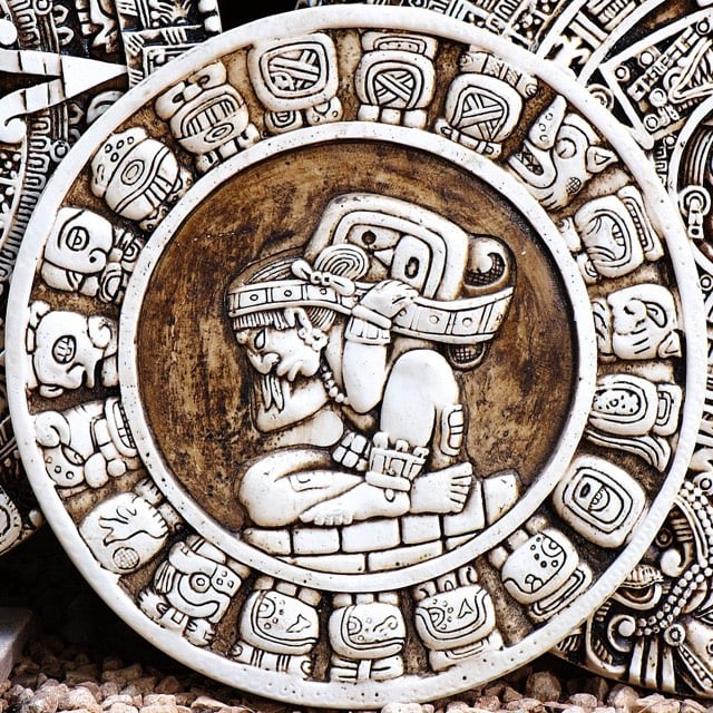
15-year-old Canadian William Gadoury has translated his interest in the Mayan civilization into two remarkable discoveries. Gadoury noticed that the locations of the biggest Mayan cities matched the locations of the stars in Mayan constellations. Furthermore, the star charts pointed to the existence of a previously unknown city, the ruins of which have since been uncovered by satellite photography.
“I did not understand why the Maya built their cities away from rivers, on marginal lands and in the mountains,” said Gadoury. “They had to have another reason, and as they worshiped the stars, the idea came to me to verify my hypothesis. I was really surprised and excited when I realized that the most brilliant stars of the constellations matched the largest Maya cities.”
Someone start a Kickstarter campaign so that he can visit those ruins! (via @delfuego)
Update: Due to a mislabeled file on Wikipedia, I used a photo of an Aztec compass instead of a Mayan image. I have replaced with an image of the Mayan zodiac.
Also, per my post about media coverage of science yesterday, I’ll point out quickly that there’s much to be skeptical about re: this story (see this post from a Mesoamerican archaeologist). More likely than not, there’s a Mayan scholar mailing list going bananas right now…I’ll let you know if I hear anything specific.
In the meantime, this story in the Independent contains some satellite photos of the location in question. (via @gunnihinn)
Update: Vice: That 15-Year-Old Kid Probably Didn’t Discover a Hidden Mayan City.
The rectangular feature seen on satellite is likely an old corn field (it’s not the right shape to be a pyramid). There are indeed ancient Maya sites all over the place, and satellite imagery and LiDAR are being used to discover them, but this doesn’t seem to be one of those cases…
On the bright side, the “if it sounds too good to be true, it probably is” study has been successfully replicated again. Science rolls on…
Sarah Parcak is a space archaeologist. She looks at infrared aerial photography for evidence of human activities that have been covered up by the march of time. Last year, Parcak located a site in Newfoundland that showed “possible man-made shapes” and may be the site of a Viking settlement from 1000 years ago.
The new Canadian site, with telltale signs of iron-working, was discovered last summer after infrared images from 400 miles in space showed possible man-made shapes under discolored vegetation. The site is on the southwest coast of Newfoundland, about 300 miles south of L’Anse aux Meadows, the first and so far only confirmed Viking settlement in North America, discovered in 1960.
Since then, archaeologists, following up clues in the histories known as the sagas, have been hunting for the holy grail of other Viking, or Norse, landmarks in the Americas that would have existed 500 years before Columbus, to no avail.
The History Blog has more info. Parcak won the million TED Prize last year for her space detective work. A PBS documentary, Vikings Unearthed, features Parcak’s work; it debuts online today and on TV on Wednesday.
Up until very recently, humans were thought to be the only animals who made and used stone tools, an era in human development that began roughly 3.3 million years ago. But according to this piece at the BBC, some chimpanzees and monkeys in various places around the globe have been using primitive stone tools for hundreds or even thousands of years.
Boesch and his colleagues had previously studied modern chimpanzee stone tool culture in the region. This research revealed that the chimpanzees have an idiosyncratic way of choosing and using their tools.
For instance, chimpanzees will often deliberately opt for particularly large and heavy stone hammers, between 1kg and 9kg, while humans prefer to use stones that weigh 1kg or less. Many of the 4300-year-old stone tools weighed more than 1kg, suggesting they were used by chimpanzees.
Chimpanzees also use their stone tools to crack open certain types of nuts that humans don’t eat. Starch residues on some of the ancient tools came from these nuts.
Together, these findings led to an obvious conclusion: chimpanzees have been using stone tools in the rainforests of Ivory Coast for at least 4300 years.

This is the rope seal securing the doors of Tutankhamun’s tomb, unbroken for more than 3200 years until shortly after Harry Burton took this photo in 1923. A description from National Geographic:
Still intact in 1923 after 32 centuries, rope secures the doors to the second of four nested shrines in Tutankhamun’s burial chamber. The necropolis seal — depicting captives on their knees and Anubis, the jackal god of the dead — remains unbroken, a sign that Tut’s mummy lies undisturbed inside.
How did the rope last for so long? Rare Historical Photos explains:
Rope is one of the fundamental human technologies. Archaeologists have found two-ply ropes going back 28,000 years. Egyptians were the first documented civilization to use specialized tools to make rope. One key why the rope lasted so long wasn’t the rope itself, it was the aridity of the air in the desert. It dries out and preserves things. Another key is oxygen deprivation. Tombs are sealed to the outside. Bacteria can break things down as long as they have oxygen, but then they effectively suffocate. It’s not uncommon to find rope, wooden carvings, cloth, organic dyes, etc. in Egyptian pyramids and tombs that wouldn’t have survived elsewhere in the world.
Older posts
Socials & More